Introduction
In the previous article we could see the pre-industrial evolution of Lisbon´s waterfront during the 18th and 19th centuries. We got to know the alternative visions for the port and the riverfront, and how the process to reach a final proposal for the new industrial harbor took some time and was considerably complex. As we saw this process culminated in 1887 with the final competition for the port development plan.

This article will explain how the winning proposal was developed during the first decades of the 20th century. We will also see how the industry and the port evolved, implementing new infrastructure that gradually separated the city from the river and the port.
Finally we will also a second key moment of the port-city relation, at the end of the first-half of the past century, when the waterfront starts to be specialized, segregating different functions At the same time this change allowed the implementation of urban programs on the waterfront for the first time. The changes here mentioned crafted the current image of the port and the riverfront. The final discussion at the end of the 20th century about the regeneration of the water edge and the relation with the river will be left for the next article.
Construction of the first section of the 1887 port plan
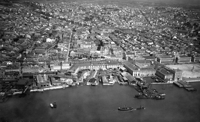
On October 31st of 1887 the construction of the new port of Lisbon began. That day was marked by celebrations both for the inauguration of the port development construction and the birthday of King D. Luis (Silva, 1923). The project was divided into 4 sectors. The first one considered the central part of waterfront, went from Sta. Apolónia railway station to Alcântara, the second from Alcântara to Belém, the third one was the eastern section of the riverbank and the 4th one was the south side of the Tagus river (Nabais& Ramos, 1987) (Costa, 2006)
The civil Engineer Hildernet Hersent was considered the winner of the competition in April 1887. His project took the one from Loureiro and Matos as starting point, but included several changes due to technical and economic issues. He was in charge for the development of the first section while the national railway company was responsible for the second one. The other two sectors were left for future construction.
The construction of the first section of the port of Lisbon was not easy and found several problems along the way. Some authors (AGPL, 1958)(Costa, 2006) have divided the process into two phases, a first one from the competition date until 1894, and he second one from 1894 until 1907. During this period the court of arbitrage was forced to intervene twice in conflicts between the contractor and the state. In 1891 the contract was reviewed, extending it for 10 years. A new contract was made in 1894 and the court of arbitrage decided in 1902 to extend the arrangement until the final date of 1907 (AGPL, 1926). Although the construction was supposed to be finished several issues affected it´s normal development, afterwards there were several works necessary to the full completion of the plan, which was not finished until several years after. In 1907 the state took control of the new port facilities and the new territory. For the management of this infrastructure the Minister of public works created an autonomous board formed by seven elements coming from the different actors involved in the port and maritime activities[1]. The new organizations was named the Administração Geral do Porto de Lisboa (AGPL). (ibid.)(AGPL, 1938) (Nabais & Ramos, 1987).
The second section of Lisbon´s waterfront included, besides the railway infrastructure, several docks, but were mainly destined to the navy or other uses rather than the usual commercial activities of the port. The landfills made in this section offered a location for the new industries related with the energy production sector. One example of this sort of settlements was the Central Tejo in Belém. This coal power plant started to be built in 1908[2] (Silva,1997). These sort of industries would remain in this part of the city until the 1940s (Costa, 2006), as we will later see.
During the first decades of the 20th century we see an increase in the maritime traffic of Lisbon. In several texts of the time we can find criticism to the development path of the port, mainly concerning the slow construction and some management issues (Silva, 1923). The construction of the first sector was not finished until 1926. During that time the existing infrastructure suffered few changes, including the transformation of the fluctuation dock into a “normal” one. In 1923 Silva complained about the delays in the completion of the works, the lack of new investment in machinery, the fact that the 2nd sector could not be used for real port activities, but only railway connection, leisure sailing or industrial areas. He also criticized that the 3rd sector was plan but never financed and the 4th section not even discussed.
Political Context
The first quarter of the 20th century was a period of political instability in Portugal. This situation did not contributed to the conclusion of the first port project and the development of the other sections. The increasing tension culminated in the assassination of the king D. Carlos I and his son and successor in the throne D. Luis Filipe in 1908. On October the 5th of 1910 the 1st democratic republic of Portugal was declared. During the following years the new regime was as well characterized by a very instable democracy with many changes in government. Finally in 1926 a coup d’état ended the democratic republic and started the military dictatorship. From 1928 to 1933 the regime evolved to become the “Estado Novo”, being António de Oliveira Salazar the key figure. First invited to the government of 1928 to be the minister of finance, gradually increased his influence until he became the president of the board of ministers in 1933, establishing the authoritarian regime that would rule Portugal until the revolution of 1974 (Saraiva, 1996) .
First decades of the 20th century.
In 1907 when the state regained control of the new port the infrastructure consisted in seven docks, with the correspondent technical apparel, a territory including 3500 m of ramps and embankments, 4700 m of piers, two dry docks, and over 14 000 m2 of warehouse space (AGPL, 1938). According to some texts of the time, during the following decades less construction was done, the interventions were mainlythe two new ship repair docks, more storage space and the conclusion of the pier of Santos.
The image of the port as it is known nowadays, started to be forged during this time (Costa, 2006). The separation between the city and the port became stronger and the difference of scale reduced the interaction between the citizens and the port.
The political climate during the 1910s and early 1920s affected as well the port development. Until the new regime gained power and a certain stability was found, there were not many relevant constructions. During the late 1920s and 1930s the new government pushed further port development. The third section, planned in the competition, and already designed in 1916, was finally under construction. The dry docks 3 and 4 for naval repair were built, and the Alcântara and Santos docks were also rebuilt[3]. The construction quality of the first section of the port was far from ideal and different reinforcement works were necessary in the following years after its opening (ibid.) (Silva, 1923).
During this time other relevant infrastructures were built on the land side. The new buildings were designed with the predominant style of the time, the Português Suave[4] (Fernandes, 2003). This architectural expression, very valued by the regime, was chosen for many public constructions of the time. This style was related with the international movement known as rationalism, mainly used other countries with fascist dictatorships. This architectural language was used by the regime as propaganda to communicate their ideals, emphasizing the national identity. As result several relevant port buildings were constructed with this style, particularly the ones that hosted functions related with the public or that had a prominent location in the port-city interface.
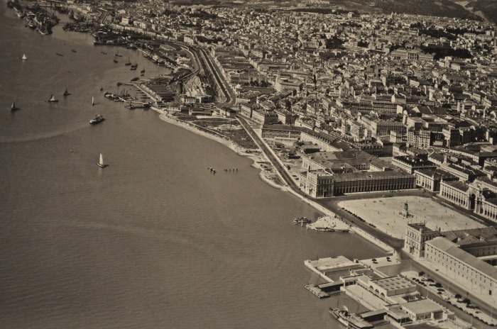
The maritime stations
The passenger traffic, both regional and international, was quite relevant for the port of Lisbon. In 1937 more than 350 000 persons arrived or departed from Lisbon by boat (Brito et al. 2007). Three maritime stations were planned during the 1930s, but only two were finally built during the next decade. The maritime stations of Alcântara and Rocha Conde d’Óbidos are two examples of the mentioned architectural style and had an important role in the city´s structure, being the doors to Lisbon for the foreign passengers. Both buildings were designed by Pardal Monteiro, an important architect of the 20th century in Portugal, and the one in Alcântara included murals by AlmadaNegreiros, increasing their artistic value. The first one was inaugurated in 1943 and the second one was built between 1945 and 1948 (Gama, 1997). These stations remained the main connection with foreign countries until the construction of the airport. Afterwards were used mainly to welcome cruise ships.


To respond to the increasing traffic of people crossing the river from north to south several stations dedicated to the passenger fluvial traffic were planned. The first one was the south-southeast stations next to Praça do Comércio, by Cottinelli e Telmo in the late 1920s (ibid.). Several years later, inaugurated in 1940, another one in Belém was built. In this case the project was by Caetano de Carvalho, in the same style the stations from Rocha Conde d’Óbidos and Alcântara would be built in the same decade. This terminal was linked with the railway station in Belém, and also played an important role in the Exhibition of the same year that we will later explain (ibis.)

Another interesting building was the refrigerated warehouse for cod fish, placed next to the rail line and the Av. 24 de Julho. This construction of large proportions had a strong visual impact due to its proportions and the architectural language including, a bas-relief with national heroes. We can see in the architectural expression or texts of the time that the port was still a an important element of civic pride was.
“(…) O que seríamos se esta esteira maritima nos nãos facultasse o precioso acesso ao Oceano e daí para todos os mares?O que seríamos sem este rio que preparous para os mares traiçoeiros os primeiros navegadores? A importância cital de Lisboa, não só para os portuguese como para o estrangeiro, é de tal modo, que a Europa não teria outra entrada fluvial para o comércio africano e americano se este pôrto não fosse como é.”
Sanches(216: 1944)
In the same decade a relevant change regarding the jurisdiction of the Port of Lisbon took place. The AGPL gained control over the entire Tagus estuary, including the south side, from Alcochete until the bar of Lisbon (AGPL, 1938). This decision should facilitate the expansion of the port and port related industries to the south side. The possibility of moving certain activities to the other bank of the Tagus nurturedthe idea of releasing some sections of the waterfront in the north side to public use, regaining an access to the water for the inhabitants[5]. Several authors discussed this issue, particularly in the section between Cais do Sodré and the Customs, that included the Praça do Comércio[6] (Cid de Perestelo, 1938). In this same sector was the navy arsenal, one of the possible activities to be relocated to the south side, as eventually did happen.
“esta zona marginal debe ser aproveitada pelo municipaio para a construção de um jardim miradouro sobre o tejo, para o embelezamento da cidade e o gozo dos Lisboetas, visto os armazens do porto terem ocupado os antigos passeios marginais.”
Curado in O porto de Lisboa. Ideias e Factos (1928)
The expansion of the port towards the east in the third section included the construction of another 910 m of quays, 3830 m of stone slopes, 46 000 m2 of quayside area, a new dock, and 800 000 m2 of usable surface (Cid de Perestelo, 1938). The third section allowed as well the expansion of large industries in the east, later on enabling the transfer of the gas factory from Belém to Matinha, and the creation of the new avenue parallel to the river, Av. Infante D. Henrique.
During the 1930s and 1940s , once the regime had achieved a certain economic stability, the law for the economic recovery (Lei de Reconstituição Económica nº1914) was passed, planning the expenses for the following 15 years in the key infrastructure (Saraiva, 1993). The port received considerable investment for machinery and at the same time the different activities started to be more segregated. The development of the eastern section facilitated the settlement of larger industrial conglomerates in this area of the city, gradually releasing the western area, mainly Belém, from these activities. This way the urban programs existing in this section were enhanced, leaving this area with a representative function, related with its historical meaning and political connection (Costa, 2006).
If the first decades of the 20th century there were few planning initiatives regarding the port and the city. However, during the 1930s and 1940s, we could see several new plans that would affect the development of the waterfront. The first major urban intervention was the 1940 Expo, that implied the regeneration of the area adjacent to several national monuments such as the Jerónimos monastery and the Torre de Belém, the ex-libris of the city, that since the end of the 19th century until that decade had been surrounded by heavy industrial facilities diminishing its visibility and impact. At the same time, during the1940s, the first Masterplan for the city was being discussed. For this new document international experts were consulted to improve the existing urban environment and to organize the expansion of the city. Simultaneously, between 1943 and 1946, the port of Lisbon expansion plan was prepared. This document would set the path for the port development during the following decades. Also during this period the ZIP (Zona Industrial do Porto – Industrial Zone of the Port) was presented. We will discuss these different document and interventions in the following lines.
Major waterfront interventions in Lisbon during the 1930s and 1940s.
At the end of the 1930s and during the 1940s three key projects affecting the waterfront of Lisbon took place: the move of some industrial facilities from Belém to the eastern area of the city, the conclusion of the Tagus avenue in front of the Praça do Comércio, eased by the new location of the navy yard in the south side of the Tagus, and the Expo of the Portuguese World in Belém. These interventions had a significant impact in the image of the waterfront and would remain as the main projects on the by the riverside until the 1980s when the issue of the relation with the Tagus would be brought back to discussion.
Relocation of the energy industries from Belém to Matinha.
Before we have seen how, during the 1930s and 1940s, the third section of the port plan started to be develop. This area was already an important industrial core, that had grown linked with other structural element of the territory, the railway. The junction of both infrastructures potentiated development of larger industrial facilities in this area (Costa, 2006).The possibility of new industries eased a certain separation of activities on the waterfront, leaving the western section for leisure, culture and other urban activities. In 1937 the Ministry of public works issued an official statement in which insisted in the idea of releasing the area adjacent to the tower of Belém from the industrial facilities. The relocation of the CRGE (CompanhiasReunidas de Gás e Electricidade) gas factory from the west side of Lisbon, where it had existed since 1888, to Matinha, in the eastern section of the city, had been previously decided in 1935 with the law 25.726. This bill stated the need to move the industry and to regularized the edge of the river in the oriental section of the city, improving the connectivity of this area (Folgado, 2015).

Finally the change only took place in 1944 (Costa 2006). The issue of the location of heavy industries next to this important landmark had been subject of controversy, criticism and public discussion since the end of the 19th century[7]. Not been even clear what was the need of such a facility in this place considering that there were others providing the same service (Ramos, 2004). In 1910 the tower received the status of national monument. The change here described was one of the firsts concerning the new uses and the programs to be implemented in the west part of the city. During the following decades the transfer of industries from west to east continued, accentuating the different roles of each part of the city (ibid.)


East-West connection on the waterfront
In the central section of the waterfront, from Cais do Sodré to the customs – placed in the eastern section of the Praça do Comércio – the landfills proposed in different plans were never executed. The main issue in this area was the connection from the east to the west part of the city. The plans presented during the second half of the 19th century often included a railway or a road in front of the square. In the previous article it was clear that this issue was particularly complex. The historical meaning of the place, named by described by Costa (2006) as representative pier, and the difficulties caused by the presence of the navy yard delayed an intervention until the late 1930s.


Finally, the new location for the navy was decided during this decade, the facilities would be relocated to the south bank, in Alfeite, next to Seixal. The long awaited connection was, after several decades, technically possible. Although in previous plans a railway linehad also been discussed, the final solution was the construction of a road. The new avenue, executed in 1939, connected the two railway stations, from Cais do Sodré until the Sta. Apolónia. Linking in this point with the newly planned Av. Infante D.Henrique. The new road was possible due to the development of new landfills, until that moment the buildings were literally on the edge of the river.
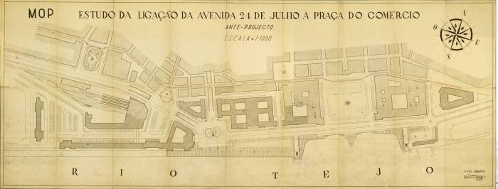
In the late 1940s a new plan for this area that was made, but never developed. In 1947 a design by Faria da Costa was released. In the project it was planned a regeneration of the area previously occupied by the shipyard, the redevelopment of Cais do Sodré, including a maritime station next to the railway one, and a tunnel connection to Restauradores Square. This intervention planned the creation of new monumental square in Cais do Sodré with two new 14 floors buildings, where the AGPL headquarters were supposed to be located (Pedras, 2014). In the drawing we can also see how the Tagus edge would be rethought, including new public spaces next to the water.
Although the development of the landfills along the entire waterfront damaged the relation with the river, they allowed the construction of a more efficient connection between the two extremes of the city, including the incipient public transport (Costa, 2006). At the same time, the East-West axis, running parallel to the river, consolidated the barrier of traffic and infrastructure between the river and the city.
As we saw in the previous article the Tagus avenue was an old ambition of some port and urban planners. Several times projects with a certain grandiosity were dreamt. The riverside road was eventually completed, connecting the eastern section of the city with Algés in the western boundary, but with less impact than what it was conceptualized (Barata, 2010). The main concern remained the efficiency as a key element of the road network of the Portuguese capital.
The issue of crossing the downtown, the Baixa, has remained one of the biggest challenges until today. The construction of underground connections has been discussed several occasions during the last 50 years, but the road intervention of 1939 has remained has the main east-west axis on the waterfront.
1940 Portuguese world Expo
The new regime of the Estado Novo had been in power since 1928. During this time there was a certain quest to praise the national pride. The history brought an opportunity to uplift the Portuguese spirit, since in 1940 there would be the possibility of celebrating a double anniversary. In 1140 D. Afonso Henriques was recognized as the King of Portugal, remaining this year as the official date for the foundation of the country. In 1640 Portugal regained its independence from Spain (Saraiva, 1996). At the same time there was the goal of establishing Lisbon as the capital of the empire (França, 1997). The colonies still played an important role in the political and social debate, it seemed necessary to have a metropolis that would represent the grandiosity of the overseas territories.

In 1932 the first discussions regarding the celebration of an international expo began to take place, but only in 1938 an official statement regarding the approval of the “Celebration of the Centenary of the Nationality” was published (Costa, 2015). The original idea was to create facilities that later would remain and be practical for the city. However, the tight deadline and the delay in the decision making process obliged to build temporary pavilions that later would be dismantled. Only in 1939 the final model of the expo was shown to the head of state, Salazar, leaving one year for the construction of the facilities (Acciaiuoli, 1998).

The location of the exhibition, in the western part of town, was clear since the beginning, being the only doubt if it would be in the landfill in front of the Junqueira, where the Cordoaria is, or if it was better in the land in front of the Jerónimos monastery. Finally the greater historical meaning of the second prevailed, playing the monastery a key role in the planning and image of the event (Nobre, 2010). In this location the plan for the Expo used an area of 45 Ha to implement its program[8] (ibid.). It was seen by the masterminds behind the project, mainly the Cotinelli e Telmo and the mayor and minister of public works Duarte Pacheco[9] (França, 1980), as the opportunity to reconnect the historic monastery with the river with square of great proportions. The intervention changed the scale and perception of Belém, bringing a new sense of monumentality contrasting with the previous smaller dimension of the popular architecture (ibid).This location was the first place along the Tagus where a new kind of relation with the river was established.

The exhibition, which opened its doors on June the 23rd of 1940, was organized around the main square (Praça do Império) with clear boundaries. There were pavilions dedicated to different topics, from the former colonies and overseas territories or invited countries, to the national history, the traditional culture and the newest developments in the railway and the port. In the exhibition there was a conjunction of different architectural styles that somehow expressed the duality of the regime´s image. On one side there was the intention of establishing an imperial character, in line with how other fascist regimes were doing in Europe, but at the same time there was a certain exaltation of the popular/vernacular architecture from the traditional village, as the source of the Portuguese values. This dichotomy was visible comparing some of the main pavilions with the reconstruction of a Portuguese village as part of the exhibition. Ironically one of the main critics to the event, at the time and still nowadays, was the fact that to release the land necessary for the new construction and the imperial square a considerable amount of demolitions were required. The buildings that were destroyed were a part of the traditional urban fabric of Belém (Nobre, 2010). Another replica that became one of the highlights of the exhibition was the “Portugal” ship, an imitation from a 16th century galley. The boat was docked in the Belém dock during the exhibition. (Acciauli, 1998).

One of the main intervention that improved the connection with the water were the new crossings of the barrier that separated the river from the city. These bridges had as well a predominant role in the image of the event. They functioned as the east and west gates of the Expo. Another project with the same goal was the pedestrian tunnel placed near the dock of Belém. By the river, next to the new tunnel and symmetrical to the dock, a water mirror with a restaurant was built, giving the impression that the river was nearer to the city in that point. This restaurant, along with the museum of ethnography, has been one of the few remaining buildings of the exhibition. They were adapted to be used after the exhibition.

One of the most remarkable projects was the “Padrão dos Descobrimentos”, a monument to honor the memory of the great explorers. This sculpture of considerable size, 50m high and 695 m2 of surface, was originally built to be dismantled after the exhibition, but since it was a significant success it was afterwards rebuilt, (re)inaugurated 1960 (Acciaiuoli, 1998). The location of the statue, directly on the river edge, between the dock of Belém and the aforementioned water mirror, is, in the opinion of the author, a key decision in the relation of the city with the water. The river edge is no longer just for industrial or port activities, but can be used for cultural programs or artistic interventions. Also the presence of the new monument created a new language, following the example of the tower of Belém, vertical elements with considerable proportions, placed by the river, giving a certain visual rhythm to the waterfront, particularly in the western section.

In terms of architecture the exhibition was considered a success. Under the direction of Cottinelli e Telmo several pavilions were exercises of creativity and helped to expereiment with aforementioned national style. Some of the architects and artists that participated in the event were: Cristino da Silva,Carlos Buigas, Lacerda Marques, Antonio Lino or Antonio Duarte, just to mention few of them.
The Expo did not attracted the number of visitors it was expected[10]. However, the event did helped the local and national governments to implement a series of large projects inLisbon, crucial for the development of the capital (Pedras, 2014). In the local scale the Av. da India became an important axis due to the connection with the Av. 24 de Julho and Marginal (Nobre, 2010). Some other examples are the road network connections to Cascais, both the riverside road and the highway, the national stadium in Jamor, the park of Monsanto, the airport, and the maritime stations above mentioned, that were aimed to receive the international guests of the exhibition. Many of these projects were only finished during the next decades.
During this decade the waterfront suffered significant changes. The project of the Portuguese Expo was in some aspects a predecessor of what would happen in the post-industrial port-cities (Costa, 2006). This operation was the most successful cooperation between the Municipality and the ministry of public works, both lead by Pacheco, and also one of the key examples of the “New Lisbon – Capital of the Empire” (Elias, 132: 2013). Although Belém suffered important changes in its urban structure, there was the goal to leave “useful” facilities and there were plans for what would happen once the exhibition was over, after the event the area remained as an expectant space, without a clear program (ibid.).
Plano Director de Lisboa – Plano de Gröer
During the 1930s and 1940s the authorities of Lisbon Municipality were aware of the need to plan the expansion of the city and to transform it into a capital of the 20th century. The demographic growth was a significant challenge, the population grew from 486 000 in the 1920s to 709 000 in the 1940s (Pedras, 2014). During the first decades of the regime several international experts were consulted for the development of Lisbon. Forrestier in 1927 presented a plan for urban improvements which included several changes that eventually did took place, such as the relocation of the nay arsenal to the south bank of the Tagus or the connection of the Av. 24 de Julho with the Praca do Comércio (Barata, 2010). Later on, Donald Alfred Agache was as well called for the development of the Plano de Urbanizacao da Costa do Sol[11]. This internationally acclaimed planner would afterwards recommended Etienne de Gröer[12] for the development of the urban masterplan (André, 2015).
The year 1938 can be considered a turning point for the urban planning of the Portuguese capital (Silva, 1994) (Tostões, 2001). We have seen that in this year Duarte Pacheco, was elected mayor at the same time he kept his position as minister of public works. His direct connection with the government eased the flow of funds for the development of key projects in Lisbon. Besides the public financing new juridical[13] and technical capacities were developed during this period (Brito et al. 2007). One of his decision was to give to de Gröer the responsibility of developing the PGUEL (Plano Geral de Urbanização e Extensão de Lisboa – General Plan for the Urbanization and Expansion of Lisbon). The plan started to be developed in 1938 but was only approved by the municipal assembly in 1948, already with a different name, the PDCL (Plano Director da Cidade de Lisboa). The document was never officially ratified by the central government, a mandatory step, but it guided the development of Lisbon during this time and the following years (Silva, 1994).

One of the original goals of the plan when the process started in 1938 was to correct the urban development direction. De Gröer, as many others before him, believed to be a mistake to plan de growth of the city in opposite direction to the river, considering it the” main beauty element of Lisbon” (Silva, 15:1994 ). Forrestier had already defended this idea before, recovering the old aspiration of building an avenue by the Tagus. The new plan for Lisbon might have been influenced by the plan for the Sun Coast. This document enhanced the development of the capital towards the west, connecting with Estoril and Cascais. De Gröer implemented some of the concepts that had influenced his education, such as the principle of the Garden City, an anthropomorphic organization with strong zoning (Brito et al., 2007). The key ideas in the PDCL according to Silva (1994) were:
- Create a radiocentrical road network
- Organize decreasing population densities from the city center towards the periphery.
- Create an industrial area in the eastern section of the city, lied with the port development.
- Build a bridge crossing the river, linking Poço do Bispo with Montijo. Connected with one of the circular roads.
- Build an international airport in the north area of the city.
- Create a new monumental axis from the Av. Antonio Augusto Aguiar towards the road to Porto
- Create a green ring around the city, from the new park of Monsanto to Loures until the river.
The two most relevant ideas for the port-city relation were the goal of reconnecting the city with the river and the development of industrial areas in the eastern part of town. The interaction with the port activities was not one of the main issues, the discussion around this topic was limited to the connection with the national infrastructural network. The main concerns of this time in the capital were the housing needs, planning the predicted expansion and establishing the main road network of the city (Silva, 1994). This plan would eventually have an important influence in the development of Lisbon and the documents that were developed after. It created the image of the city that we know today (França, 1997).
Port changes in the 1940s
During the 1940s several bills were published that structured the port development in the national and local context. In 1942, following the ideas of the de Gröer plan previously explained, the bill 19/10/1942 was approved, which stated that the eastern section of the city should host the bigger industrial facilities. This bill demanded new infrastructure from Poço do Bispo to Matinha first, and after until Beirolas, already in the limit of the city. Associated with this development several important industries were established, such as the Gas factory in Matinha, Oil refineries in Cabo Ruivo, the slaughterhouse of Lisbon, the milling of Lisbon and the factory and deposit of war material, all of them in Beirolas (Nabais & Ramos, 152, 1988). This industrial development of the eastern section of town was complemented on the south bank with the bigger autonomous industrial complexes, affecting the port economy and territory. They were the Quimigal in Barreiro and Lavradio, the Siderurgia Nacional (National steel plant) in Seixal, and the Lisnave shipyards of in Almada (Costa, 2006).
In 1944 the national government passed the law DL 33922 5/9/1944, responsible for the 2nd phase of the national port plan. The port of Lisbon was not included in this document since it was considered that it required a separate plan due to the size and complexity of the infrastructure. The “Plano de Melhoramentos do Porto de Lisboa”- Plan for improvements for the port of Lisbon, was approved on the 24th of June of 1946, with the bill DL 35716. This new document, besides setting the path for the port development, also assigned the necessary financing. The key works included in the plan, many of them related with the aforementioned industrial area, were: In the eastern section: the construction of new piers and dock in Poço do Bispo, new pier in Xabregas, regularization of the coastline between Matinha and Cabo Ruivo, and Cabo Ruivo and Beirolas, including the new dock of Olivais (destined to work as maritime airport). Also new warehouses and industrial facilities were planned, such as the refinery of Cabo Ruivo. In the western part, the main project was the dock of Pedrouços, dedicated to fishing activities, also known by the name of the managing society Docapesca. New landfills on sludge areas were also planned, with the goal of improving the general hygiene of the port and the city. On the south side the main intervention was the regularization of the coast line between Cacilhas and Alfeite (Nabais& Ramos, op. cit).

Finally, in 1948 another relevant law was passed. In the 2nd article or the DL 36976 20/7/1948, the jurisdiction of the AGPL was updated and increased, including 110 km of riverbanks. The new boundaries were the bridge of Vila-França de Xira, on the east, and the line defined by the fortresses of S. Julião e Bugio on the west. This area included 50 km of river banks on the north side and 60 km on south. The area and river edge controlled by the AGPL had borders with 11 municipalities.
1940s – 1974
The period that goes from the late 1940s until the end of the regime, in 1974, was characterized by the implementation of national plans for the development of the country and the key infrastructure. These plan were also known as the “Planos de Fomento”. During this time three main plans and a partial one were prepared. The first one went from 1953 until 1958, the second from 1959 until 1964, then the intermediate plan, from 1965 until 1967 and finally the third development plan from 1968 until 1974. These documents set the path for the key investment in the main infrastructure and also influenced the urban development strategies (Silva, 1994).
The Port
The first development plan (1953 – 1958) was mainly focused in financing and completing the projects scheduled in the document from 1946, without major innovations. The second development plan (1959- 1964) was focused in general interventions to improve the conditions of the port and be able to host the bigger ships, mainly in the third section. In this plan the Docapesca in Pedrouços was one of the project that received more investment, mainly with new buildings and facilities for the fishing activities (Nabais, Ramos, 1987). The infrastructure for fluvial traffic, mainly the ferries, was also improved. In this second plan was also foreseen the change of use of the dock of Bom Sucesso, in Belém, from navy activities to nautical sports and leisure.
The strategic investment decided in these plans had a clear goal of gradually increase the industrial activity in the country. During the 1950s and 1960s we see how the municipalities next to Lisbon received financing to develop key infrastructure, easing the path for the private sector. During these decades the large industrial conglomerates in Lisbon metropolitan area, mainly in the south side of the Tagus as we have already seen, grew from a local/regional scale to compete in the Iberian market (Costa, 2006). The industrial facilities employ thousands of workers in activities related with the petrochemical sector, steel plants and shipyards.
Finally, during the 1970s, the port started to receive container traffic. This new type of cargo, in use since1950s, gradually gained more importance in the international logistic chains. The first terminal prepared to handle this kind of traffic was the one in Sta. Apolónia, adapted with the necessary technology since October 1970. This change opened a new phase in the history of the port activity and the relation between the port and the city (Nabais & Ramos, 1987).
Mas os efeitos da escala ainda tardam, pois a revolução da contentorização só se impõe no Porto de Lisboa, a partir de 1970. Esse é o momento da criação de uma autêntica barreira física na Lisboa ribeirinha, desde Cabo Ruivo àAlfândega.
Folgado & Custódio,1999
Only later, in 1985, the dock of Alcântara would be prepared to handle containers. This terminal was, and still is, operated by a private company named Liscont, working with a concession contract.
The urban development and plans from 1940s until 1970s
After the de Gröer document, and until the end of the regime, other two plans were prepared to tackle the urban development of Lisbon. Both of them used the previous plans as the base for their work, establishing a certain continuity with core ideas, but, at the same time introducing key changes that would shape the future of the Portuguese capital. Another common feature is the fact that both were approved in municipality, and guided the development of the city, but were either never or much later approved by the central government.
The plan published in 1959 (PDUL – Plano Director de Urbanização de Lisboa) was a revision from the one of 1948, with few new concepts and ideas. From an initial vision closer to the garden city in 1938, it evolved to embrace the concepts defended in Athens Charter. One of the key changes was the relocation of the connection between Lisbon and the south side of the Tagus. Instead of placing it in the eastern sector of the city, it was planned between Alcântara and Almada. The bridge would eventually be built in this location, but only opening to the public in 1966. New road connections, including two urban highways, were also planned, enhancing the role of the car in the society. This plan was led by Guimarães Lobato.

The second plan started as revision of the previous one, led by George Meyer Heine, but eventually it became a new full plan, approved in 1967 by the municipality. This new document, also known as the PDUL, had to deal with the increasing traffic of vehicles and the evolution of the demographics. At the same time the new plan identified several issues related to the previous development. The radio-centrism was considered a problem, the delays in some key infrastructure was affecting the urban development of the city, and there was a deviation between the expected population in the existing plans and the real one. The recently inaugurated infrastructure, such as the subway system and the new bridge, required new strategies for the city. The plan proposed a new south-north highway, connecting the Salazar bridge (today known as bridge 25 de Abril) with the airport. A new monumental axis, like in previous plans, from Av. Da Liberdade, was also planned. The concept for distribution of population densities changed in comparison to the previous documents, from a model that defended a decrease from the center to the periphery, to establish an uniform distribution of the population. This plan was only approved by the national Government in 1977 with the ministerial ordinance n.º 274/77, of 19 of May.


In the map of the plans we can see that the port area is considered outside the boundaries of the municipal control. The AGPL (nowadays known as APL) was, and still is, a central government body, responsible for the management of a territory that belongs to the state, not the city. For this reason, the connection and interaction between both institutions, and also between the different plans, has been often limited to the connection nodes necessary for the infrastructure. In the last plans we see a more functionalist approach, where the relation with the river is not as important as it was previously considered. The debate about the interaction between the Tagus and Lisbon would only be recovered in the late 1980s and early 1990s. Both realities, city and port, regained a certain need to cooperate and to find a way to give to the city and citizens a new contact with the water.
Conclusion
The main goal of this research is to discover how the relation between the port and the city has worked in the context of Lisbon and it can be improved. It is widely accepted that to understand our present and plan our future it is necessary to comprehend the past, the path that has taken us to our current situation. In these three articles, the two written so far and the next one, we try to understand how have the port and the city evolved during the last 300 years. We have seen that the international models presented by other senior researchers are more or less accurate in Lisbon, although with slightly different timeline. We can also observe that in the history of this port-city, as in many others, the evolution is not lineal, but rather marked by long periods of stagnation interrupted by moments of intense activity. However, the evolutions does not stop. Since 1755 we have seen how a myriad of small piers evolved into a large industrial port. How in the process several alternatives for more balanced port – city – river – citizen alternatives were dismissed. We could identify the break up moments, the change from a local industry to international, the changes in the waterfront. In the process we have also seen how in the first transformation of the waterfront, the public space regained a lost central role, and how, at the same time, the segregation and intensification of port activities could have caused a certain sense of negligence in the areas of the city that hosted these activities. This last issue, particularly clear since the arrival of the container traffic, along with the infrastructural barrier could be one of the reasons causing the distancing between both realities.
In the following article we will see how the riverfront debate becomes once again a hot topic in the public realm. Since the 1980’s there have been several planning initiatives to recover the city – river relationship. But then, what role has the port played? What were the key concept of this rapprochement? The port remained as a barrier or became an active element of change? In the past decades there has been considerable research done related with this topic, from Master and PhD investigations to architectural and urban planning competition, even initiatives focused in the cultural value of the port and the river. We will see all these activities before we focus in the analysis of the current situation and we try to formulate possible solutions.
References
André, P. (2015). A CITY MADE OF CITIES Lisbon in the first half of the XX century: new Lisbon (1936) and Lisbon new (1948). Urbana, Cec. Unicamp, 7(10), 89–111.
Acciaiuoli, M. (1998). Exposições do Estado Novo 1934-1940. Lisbon: Livros Horizonte.
Barata, A. C. M. (2010). Lisboa “Caes da Europa”: realidades, desejos e ficções para a cidade (1860 – 1930). Lisboa: Edições Colibi – IHA/Estudos de Arte Contemporânea, FCSH – Universidade Nova de Lisboa.
Brito, V., & Camarinhas, C. (2007). Elementos para o estudo do Plano de Urbanização da Cidade Lisboa. Cadernos Do Arquivo Municipal de Lisboa, 164–189.
Costa, J. P. (2006). La ribera entre proyectos : formación y transformación del territorio portuario, a partir del caso de Lisboa. Barcelona : Universidade de Catalunha.
Costa, J. P. (2007). A renovação urbana dos grandes complexos portuários do século XX: novos territórios, novas dinâmicas. Portus, (14), 4–7.
Costa, J. P. (2008). Cinco gerações de renovação urbana na ribeira de lisboa. Estuarium, 12–17.
Costa, S. V. (2015). Pensar Lisboa. A obra capital de Duarte Pacheco. Rossio – Estudos de Lisboa, (5), 84–97.
Curado, B. De P. (1928) O Porto de Lisboa. Ideia e factos.Livraria Rodrigues. Lisbon.
Elias, H. (2013). A monumentalização de Lisboa ocidental: arte pública e intervenções urbanas na frente ribeirinha de Belém. Rossio – Estudos de Lisboa, (2), 130–141.
Folgado, D., & Custódio, J. (1999). Caminho do Oríente – Guía do património industrial. (J. Sarmento de Matos, Ed.). Lisbon: Livros Horizonte.
Folgado, D. (2015). Lisboa industrial. Um caminho da e para a modernidade. Rossio – Estudos de Lisboa, (5), 98–109.
França, J. A. (1980). Lisboa: Urbanismo e Arquitectura (1a ed.). Lisbon: Instituto de Cultura e Língua Portuguesa Ministério da Educação e Ciência.
França, J. A. (1997). Lisboa: urbanismo e arquitectura (3rd ed.). Lisbon: Livros Horizonte.
Gama, E., & Miranda, I. (1997). Lisboa ribeirinha e as suas estações – síntese histórica. In A. Caessa & M. G. Martins (Eds.), Actas das sessões do II Colóquio temético Lisboa Ribeirinha (pp. 201–224). Lisboa: Câmara Municipal de Lisboa – Departamento de Parimonio Cultural Divisão de Arquivos.
Lobo, L. M. (1976). Porto de Lisboa (1963-1974). AGPL. Lisbon.
Mangorrinha, J. (1999). Papéis de(o) Arquitecto na intervenção municipal urbana: notas sobre projectar Lisboa no século XX. Cadernos Do Arquivo Municipal, 1(3), 216–229.
Matias, R. (Ed.) (1961)O porto de Lisboa , in: Portugal de Hoje(1). Eco. Lisbon.
Nabais, A. J. C. M., & Ramos, P. O. (1985). Porto de Lisboa: Subsidios para o estudo das obras, equipamentos e embarcações na perspectiva da arqueologia Industrial. AGPL – Administração Geral do Porto de Lisboa. Lisbon.
Nabais, A. J. C. M., & Ramos, P. O. (1987). 100 anos do porto de Lisboa. Lisboa: Administração do Porto de Lisboa.
Nabais, A. J. C. M., & Ramos, P. O. (1991).Referências Históricas do Porto de Lisboa. Administração do Porto de Lisboa. Lisbon.
Nabais, A. J. C. M., & Ramos, P. O. (199x?). Roteiro das fontes da História do Porto de Lisboa. Administração do Porto de Lisboa. Lisbon
Nobre, P. A. (2010). Belém ea Exposição Do Mundo Português: Cidade, Urbanidade e Património Urbano. Universidade Nova de Lisboa.
Pedras, M. R. (2014). Uma Capital para o Império: a Lisboa sonhada do Estado Novo. Rossio – Estudos de Lisboa, (4), 198–215.
Perestelo, A. M. C. (1938) in Cinquentenario da inauguração das obras da1ª secção do Porto de Lisboa, feita em 31de outubro de 1887. Discursos proferidos na sessão solene de 30 de outubro, presidida por S. Exª o Presidente da República, Sr. General Antonio Oscar de Fragoso Carmona. Administração Geral do Porto de Lisboa. Lisboa, Imprensa Nacional. Lisbon.
Ramos, P. O. (1992). Lisbon’s Historic Waterfront. Industriekultur Und Arbeitswelt an Der Wasserkante – Zum Umgang Mit Zeugnissen Der Hafen- Und Schiffahrtsgeschichte / Industrial Culture and Industrial Work in Coastal Areas – How to Handle the Heritage of Port and Shipping History, Arbeitshefte Zur Denkm, (11), 41–45.
Ramos, P. O. (2004). A Torre de Belém e a Fábrica do Gás – Contra o gasómetro, marchar, marchar. Pedra & Cal, (21), 12–14.
Ribeiro, O. (1987). A formação de Portugal. Lisbon: Instituto de Cultura e Língua Portuguesa Ministério da Educação.
Sanches, J. D. (1944). O porto de Lisboa através dos séculos. Lisbon.
Saraiva, J. H. (1993). História de Portugal. (F. L. de Castro, Ed.). Mem Martins: Publicações Europa-América.
Silva, J. J. C. (1923). Desorganização do trabalho no porto deLisboa e as suas consequências no custo da vida. (Tese apresentada ao congresso das associações comerciais e industriais portuguesas reunido em Lisboa e Novembro de 1923). Tip. da Emprêsa Diário de Noticias. Lisbon.
Silva, C. N. (1994). Política Urbana em Lisboa, 1926-1974. Lisbon: Livros Horizonte.
Silva, F. M. da. (1997). Tempos difíceis: a Central tejo e a cidade de Lisboa nos anos trinta e durante a II Guerra. In A. Caessa & M. Gomes Martins (Eds.), Actas das sessões do II Colóquio temático Lisboa Ribeirinha (pp. 353–361). Lisbon: Câmara Municipal de Lisboa – Departamento de Parimonio Cultural Divisão de Arquivos.
Sousa, A. A. De (1926). Le Port de Lisbonne. Commission Administrative du Port de Lisbonne. Biblioteca Nacional de Lisboa – Betrand. Lisbon
Tostões, A. (2001). O bairro de Alvalade no quadro do desenvolvimento urbano de Lisboa. In M. H. Barreiros (Ed.), Lisboa, conhecer, pensar, fazer cidade (pp. 64–71). Lisbon: Câmara Municipal de Lisboa – Direcção Municipal de Urbanismo – Departamento de Informação Urbana
Official Documents:
AGPL (1913?). The Port of Lisbon.
AGPL – Organização do serviço de Publicidade e Turismo (1958). Imagens do Porto de Lisboa. Lisbon
Ministério das Comunicações. (1943). Planos de arranjo e expansão. (Decreto.lei nº 32842). Imprensa Nacional. Lisbon.
Ministério das Comunicações. (1948). Plano de Melhoramentos do Porto de Lisboa.Tipografia Portuguesa, Lda.Lisbon
[1]The new organization was a significant innovation in the port management models existing at the time. The port of Lisbon was the first one to have this kind of structure, discussed for the first time in the 10thinternational Maritime Congress in Milan in 1905. The board included a president named directly by the government, the director of the customs in Lisbon, an engineer as chief of exploration, the chief of the central maritime department and representatives from the railway companies, the shipping sector, and the commerce. (Perestelo, 1938)
[2] The power plant “Central Tejo”, was built to provide electricity to the city and the Lisbon-Cascais railway line. There were several expansions during the following years, in some cases even adding an entire new building, like it happened in 1939 (Silva, 1997). It remained in operation until 1968 (Ramos, 1992). Several years it was deactivated it was refurbished to accommodate the electricity museum and to work as a temporary exhibition hall. The new function was implemented in 1990s,being included in what can be considered the Belém museum axis. To this axis belong as well other cultural facilities such as the CCB, the Cordoaria or the Museum of carriages.
[3] In 1919 the wall of the dock of Alcântara crawled requiring repair. For this reason reinforcement interventions were necessary. Several authors indicate that the low quality of the construction of the piers was due to the short exploration contract given to the contractor, Hersent. This issue could have forced him to build excessively fast and cheap to have a return of his investment, instead of what could have happened if the contract would have been made for a longer period allowing him to build with higher quality standards and recover his investment in a longer period.
[4]We can find buildings from the beginning of the century in Portugal designed in modernist style, such as the fluvial station from Cottinelli e Telmo. Gradually the architects started to develop the Português Suave language, very valued by the regime .This style has been studied by several serearchers in Portugal. For example it was descibed by Pedras(2015) as it follows: (…) caracterizava-se pela reaproximação a uma estética joanina, com elementos característicos como as varandas do andar nobre, as linhas austeras, a monumentalidade das entradas, os telhados em mansarda e a simetria sóbria e regular que marcava toda a edificação.
[5] During the celebrations of the 50th anniversary of the construction of the port (1938), in the speech made by Prof. Eng. Afonso de Melo Cid de Perestelo, the layout of the port, occupying the entire waterfront was criticized. It was also suggested that the central section should be left for the city to “breathe” and have a contact with the water, insisting, once again in the creation of an avenue or boulevard in front of the location of the navy shipyard.
[6] In the book “Port de Lisbonne” the possibility of relocating the navy arsenal was very clear. This publication was published by the AGPL itself to promote the port of Lisbon. We can see that even the official stand was to ease the access to the river in specific locations, such as the Praça do Comércio.
[7] There are texts from different authors and intellectuals of the time referring this topic and criticizing the municipality that approved the construction of the industries close to the Tower, authors such as Castilho, Ramalho Ortigao or Bordalo Pinheiro. For more information check the article by Ramos “A Torre de Belém e a Fábrica do Gás – Contra o gasómetro, marchar, marchar”, published in 2004.
[8] As said by Nobre (2010) there are contradictory information about the territory occupied by the Exhibition. For example Costa (2006) indicates a territory of 56 Ha.
[9] Duarte Pacheco (1900 – 1943) was a key figure in the transformation of Lisbon and Portugal during the 1930s and 1940s. He would be the minister of education in 1928 and of public works from 1932 until 1935, and once again from 1938 until his death in November 1943. He became the mayor of Lisbon from 1938, keeping both position officially only for a few months. His influence in the city and the country was much broader than this period (Costa, 2015).
[10] Some authors state that, as often happens in authoritarian regimes, the official numbers were distorted and only the first and last days attracted a considerable number of visitors. (Accialiui, 1998)
[11]The “Plano de Urbanização da Costa do Sol” (Urbanization Plan for the Sun Coast) started to be developed by Agache in 1933. This plan was created for the development of the region between Lisbon and Cascais, being the road network one of the key elements. It was the first regional plan developed in Portugal. The project remained on hold until Duarte Pacheco, in 1938, became the mayor of Lisbon and Minister of Public Works. At this point the plan was resumed by De Gröer, at the same time he was working in the Plan for Lisbon. (Costa, 2015)
[12]Étienne De Gröer was hired by the municipality between 1938 and 1940, and once again between 1946 and 1948 (André, 2015)
[13]Particularly relevant was the new legislation that allowed an easier expropriation procedure when necessary. This favorable law allowed the municipality to become one of the main urban and real estate developers of the city. It was able to get 35% of the total development area until 1951 (Franca, 1997).One of the goals of Duarte Pacheco was to keep the right to urbanize exclusive for the public institutions, i.e. the municipality. (Brito et al. 2007)
